What is making Hurricane Milton so ferocious?
Hurricane season appears to have awoken all at once, and the potentially deadly Hurricane Milton is surging towards the Florida coast. But what has made it so intense?

Hurricane season appears to have awoken all at once. In less than two weeks, two major hurricanes formed in the Gulf of Mexico with ferocious strength.
First, the massive Hurricane Helene brought torrential, deadly rains hundreds of miles away from where it initially hit land.
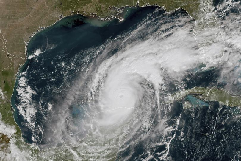
Now, Hurricane Milton is swirling toward the Florida coast, after catapulting from a tropical storm to a Category 5 hurricane in about a day — also ranking as the fifth most intense on record.
Sign up to The Nightly's newsletters.
Get the first look at the digital newspaper, curated daily stories and breaking headlines delivered to your inbox.
By continuing you agree to our Terms and Privacy Policy.While it may become somewhat weaker, it is expected to slam the Tampa Bay Region, bringing the potential for an ocean surge up to 10 to 15 feet.
Hurricanes require a lengthy recipe list to materialize, but scientists agree that one ingredient has been pushing these storms to new limits recently: ocean heat.
Waters in the Gulf of Mexico started to break all-time temperature highs this summer, but recent weeks have seen an extra jolt of warmth — what scientists describe as a “marine heat wave” that provided additional fuel to the storms.
After a lull earlier this summer, atmospheric conditions have also been more favourable for hurricane development recently.
“All summer long, different parts of the Gulf of Mexico have been in varying states of heat wave,” said Brian Dzwonkowski, an oceanographer at the University of South Alabama. “Oftentimes, in the Gulf of Mexico, it’s very warm to very deep depths.”
These abnormally warm bouts are among the most important factors when it comes to forecasting hurricane behaviour, research shows.
They can promote more evaporation of ocean water into the air - propelling storms to grow faster and stronger and drop more rain, as seen in Helene and Milton.
What is a marine heat wave?
A storm’s strength is largely dependent on atmospheric conditions above and ocean heat below. Dry air, for instance, can weaken a storm.
An extremely warm ocean can add more energy to a storm, increasing its wind speed and rainfall.
While warm water is necessary for hurricanes, marine heat waves add an extra punch.
They are periods of abnormally high ocean temperatures, sometimes lasting for days, weeks, months or years.
A common definition is when temperatures are warmer than they are 90 per cent of the time, for at least five days.
On a practical level, the aquatic heat spells are “just emphasizing there’s another extreme condition we should be thinking about” when a tropical cyclone is going through an area, Dzwonkowski said.

In recent weeks, a marine heat wave came on top of the already warm sea surface temperatures in the Gulf.
As of Tuesday, the National Oceanic and Atmospheric Administration classified the heat wave as moderate to strong (category 2 out of 5), but any amount of extreme heat is influential.
The exact causes of a marine heat wave are still an active area of study, but it can stem from increased solar heating or changing currents.
Their frequency and intensity have also increased under human-caused climate change, doubling in number in the past four decades.
“Marine heat waves are like the monsters for the future,” said Soheil Radfar, a coastal hazards researcher at the University of Alabama at Tuscaloosa. “We should be prepared against this monster that is going to supercharge tropical cyclones and make them stronger.”
Predicting rapid intensification
Milton left scientists stunned this week as it jumped from a tropical storm to a Category 5 hurricane.
Meteorologist John Morales began to choke up during his broadcast discussing Milton’s quick evolution. Scientist Jennifer Francis called the storm’s sudden pressure drop “insane.”
Meteorologist Eric Webb said the intensification rate was “nothing short of legendary.”
Milton’s remarkable behaviour was in part because of the ongoing marine heat wave, Radfar said.
He and his team found that storms between 1950 and 2022 were more likely to rapidly intensify during a marine heat wave than during periods without one - if the atmospheric conditions were also conducive.
For instance, Milton also experienced low vertical wind shear in its path, or change in wind speed and direction with height that disrupts hurricanes.

“If all the factors are favourable, there is higher chance for rapid intensification,” said Radfar. “But the most important factor is high sea surface temperature.”
At the same time, scientists say, ocean heat has increased to record levels in recent decades due to human-caused climate change.
The reason is simple: The oceans, which cover more than 70 per cent of Earth’s surface, absorb most of the excess heat created by burning fossil fuels.
Water also can absorb large amounts of heat with relatively little temperature change, making it a very efficient place to store all the trapped heat in the atmosphere.
Using computer models, an analysis from Climate Central said the record sea surface temperatures over the past two weeks were 400 to 80o times more likely as a result of climate change.
Under the heat wave, Radfar estimated Helene was 80 per cent more likely to experience rapid intensification at its location based on historical observations.
Rapid intensification is when a storm’s sustained wind speed increases by at least 35 mph in 24 hours. Helene, indeed, increased its wind speeds by at least 52 mph in 24 hours, according to the National Hurricane Center, one of the fastest rates of rapid intensification on record.
Milton was even more stark. Radfar estimated that it was 150 per cent more likely to rapidly intensify based on data showing other hurricanes that passed over that region in previous decades during a heat wave.
Milton ended up increasing its sustained wind speed by 90 mph within 24 hours — making it one of the fastest intensifications since 1979.
Some parts of the Gulf, associated with deeper, warmer currents that can amplify storms, are more conducive to rapid intensification under a heat wave, Radfar’s study found.
Helene and Milton happened to pass through the hot spots.
“For these two hurricanes, our historical observations align with what happened for Milton and Helene,” said Radfar. Milton, he said, experienced a more pronounced intensification than Helene because there were more favourable atmospheric conditions to promote hurricane growth.
Marine heatwaves not only affect intensification but also wind speed. Research shows that tropical cyclones under heat waves had maximum wind speed increases up to about 36 per cent greater than those that formed during periods without heat waves.
The tropical cyclones during a heat wave were more than twice as likely to grow into super hurricanes (Category 4 or 5) as those that did not - similar to Helene and Milton, said Myung-Sook Park, one of the study’s authors.
The extra ocean heat also added more rainfall to storms.
Even though two tropical cyclones displayed similar intensities early on, the storms passing over marine heat waves showed precursor signs of more precipitation, said Park, a researcher at the Korea Institute of Ocean Science and Technology.
Park said it was “particularly exciting” to make this new connection.
The heavy rainfall was obvious with Helene, which dropped up to 20 to 30 inches of rain in the mountains of western North Carolina. Forecasts predict another heavy round of rain with Milton in Florida.
“The stronger, stronger these storms get, the more they carry that moisture and that rain field further and further inland,” said Dzwonkowski.
Unlimited amount of fuel for Helene and Milton
Even with a widespread marine heat wave, not all warmth in the Gulf of Mexico is the same. Some areas are warmer and deeper than others, including what scientists call “the loop current.”
This current, part of a bigger gyre in the North Atlantic, brings in warm water from the Caribbean, past the Yucatán Peninsula into the Gulf of Mexico. It extends about half a mile down, creating a deep reservoir of warm water for hurricanes to tap.
This is one of the biggest sources of heat in the Gulf of Mexico.
“The loop current is usually the warmest water in the Gulf at the surface and at depth,” said Nan Walker, an oceanographer at Louisiana State University. “It’s basically an unlimited amount of heat to fuel a hurricane that passes over it.”
Any hurricane that passes over the loop current usually intensifies unless there are overriding atmospheric conditions that prevent that from happening, Walker said.
In fact, the temperature below the surface “is what’s going to really fuel hurricanes to intensify to a much stronger hurricane,” said Séverine Fournier, an ocean scientist at NASA’s Jet Propulsion Laboratory.

Part of the reason that warm, deep water is important is because hurricanes churn water from below. Usually, the water is colder and brings cooler temperatures to the surface, often stifling the hurricane.
But when the water is warmer at farther depths, then relatively warm water is brought to the surface - providing additional fuel for the hurricane.
That appears to be the story with Helene and Milton. Fast-moving Helene passed over the loop current and intensified, but the water it brought to the surface was still relatively warm.
The water “just warms again to the surface,” said Fournier, who observed a similar phenomenon during Hurricane Michael.
Scientists say it was not expected that Milton would intensify so quickly, even though it has yet to pass through the loop current.
“It is surprising that Milton went from a Category 1 to Category 5. It wasn’t even over the loop current.
That’s unheard of. I’ve never seen that happen, ever,” said Walker, who has been a researcher for about three decades. “It seems like the upper ocean of the Gulf is very warm.”
But Milton’s journey isn’t over - it’s also expected to pass through the loop current on its eastward path to Florida.
The loop current could pump up Milton theoretically, but atmospheric conditions — such as higher wind shear — are expected to counteract Milton’s growth.
The Hurricane Center forecasts that the storm will weaken before making landfall around the Tampa Bay region, though hitting at a Category 4 or 3 could still be catastrophic depending on when and where it makes landfall.
“Hurricanes are not only responding to ocean heat content,” said Fournier. “There are a lot of requirements that need to be met, especially also in the atmosphere.”
About this story
The map of the marine heat wave uses data from the Coral Reef Watch project of the National Oceanic and Atmospheric Administration.
It categorises marine heat wave at a grid resolution of five kilometres squared.
Each grid cell’s daily temperature is compared with an 11-day rolling window of daily temperatures of the 28-year period from 1985 through 2022.
For example, each grid cell’s temperature on Oct. 6, 2023, was compared with the Oct. 1-Oct. 11 temperatures over the 28-year period. If the grid cell’s daily temperature is above the 90th percentile of temperatures in the comparison data, it is considered a moderate heat wave.
If the temperature is twice the difference between the 90th percentile of temperatures and the average temperature from the comparison data, it is considered a strong heat wave.
The methodology used to calculate hurricane wind speeds during heat waves and during periods without heat waves is described in Choi et. al., 2024.
© 2024 , The Washington Post
