NASA releases imagery as volcano lava engulfs popular tourist destination amid evacuations
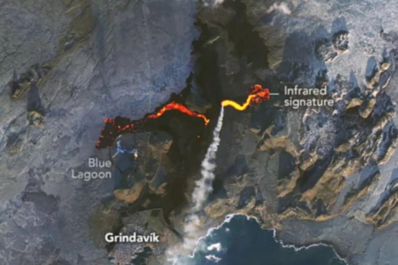
NASA have released satellite imagery showing the scale and path of destruction as lava continues to flow at an alarming rate from a Volcano in Iceland.
The image taken by OLI-2 (Operational Land Imager-2) on Landsat 9 shows the lava trail spewing from a fissure in the Sundhnúkur crater on Iceland’s Reykjanes Peninsula.
Taken on November 24, the image taken from space gives officials a clear idea of the path that the molten lava is taking as it cuts a swathe through everything in its path on the way to a final resting point in a famous tourist destination.
Sign up to The Nightly's newsletters.
Get the first look at the digital newspaper, curated daily stories and breaking headlines delivered to your inbox.
By continuing you agree to our Terms and Privacy Policy.The latest eruption began on November 20, and has produced 1.8 mile-long fissure in the ground near Stóra Skógfell peak, as it east and west toward the famous Blue Lagoon.
Constant flow of the lava has gradually engulfed the tourist destination’s carpark and continues to grow in size.
The Blue Lagoon was evacuated ahead of the lava’s arrival, as were 50 homes in the town of Grindavík, which is home to 3,800 residents.

According to the Icelandic Meteorological Office, this eruption’s activity had not decreased as quickly as was seen in previous eruptions, and was still going strong five days after the eruption began.
Iceland’s authorities are always prepared for seismic and volcanic activity which occur regularly with the department of civil protection and emergency management and local authorities saying they “activated all necessary security measures and the area around Grindavík which has been safely and successfully evacuated”.
For the past three years, the Reykjanes Peninsula has witnessed a surge in seismic activity, including ten volcanic eruptions.
The increased number of eruptions in Iceland over recent years with thousands of toruists focking to the small nation to view the volcanos.
Iceland’s government said they “monitor any seismic and volcanic activity closely in collaboration with the department of civil protection and emergency management and the Icelandic meteorological office, local authorities and partners across industry, travel and tourism”.

