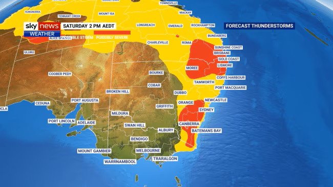
Weather bomb set to hammer Brisbane, Sydney, Canberra on wild weekend
Millions of Australian’s are preparing for a wild weekend as a massive storm front grows in intensity, ready to deliver more destructive wind gust and sheeting rain.

Millions of Australian’s are preparing for a weekend weather bomb as a massive storm front grows in intensity, ready to deliver more destructive wind gusts and sheeting rain.
South Eastern Queensland bore the brunt of the wild weather on Friday night and into Saturday morning, with most coastal areas of the eastern seaboard warned they should prepare for a drenching on Saturday afternoon and into the evening.
The Bureau of Meteorology expects the storms to intensify and has declared a range from Brisbane to Canberra all in the firing line.
Sign up to The Nightly's newsletters.
Get the first look at the digital newspaper, curated daily stories and breaking headlines delivered to your inbox.
By continuing you agree to our Terms and Privacy Policy.Friday’s storms hammered the Darling Downs, west of Brisbane, before landing on the Gold Coast late on Friday afternoon delivering in the afternoon wind gusts of over 90km/h.
“Severe thunderstorms are likely to produce heavy rainfall that may lead to flash flooding and damaging winds in the warning area over the next several hours,” the BOM warning stated.
Sky News meteorologist Rob Sharpe confirmed the weather front will bring significant storm activity to a vast region on Saturday, with three major capital cities expected to be effected.
“It’s now in southeastern parts of Queensland. It’s start of the day in New South Wales, where we saw a series of large thunderstorms bring pretty significant downpours, as much as 40 millimetres in some spots, including around the Grafton area,” Mr Sharpe said of Friday’s storms.
The “dynamic storm system in the east” is building and Saturday night should be telling Mr Sharpe explained.
“There’s that risk of damaging winds, heavy rain. The key is Canberra, Sydney and Brisbane all at risk of seeing severe thunderstorm activity.
“Powerful winds higher in the atmosphere, combined with unstable and humid air, would create ideal conditions for dangerous storms to form across the ACT and southeast New South Wales.
Queensland and far northern NSW can expect more “damaging winds, heavy rain, and large hail” on Saturday he added.
Saturday’s storms could stretch “from Mount Isa in the northwest all the way to the southeast of Queensland with a touch over the border into northern New South Wales.”
Mr Sharpe also noted an active build-up across the inland, adding there is “potential for showers and thunderstorms, some severe there as well, mainly in the southern half of the Northern Territory.”
While the storm’s focus is set to hammer the eastern states, WA are set for a lovely weekend of warm and calm weather.
Following Saturday’s burst the expectation from meteorologists is that the front will dissipate on Sunday, with storms giving way to more consistent rain through parts of Queensland, inland Northern Territory and northern NSW.

