Tropical Cyclone Alfred news and updates, Friday March 7
RECAP: Cyclone Alfred is less than 100km away from Brisbane and 75 km north-east of Gold Coast, meanwhile a search is underway for a man missing in NSW floodwaters as the impact of Alfred worsens.
Stay in touch with all the latest news in posts below.
Key events
07 Mar 2025 - 06:04 PM
Latest emergency advice and updates
07 Mar 2025 - 04:21 PM
PM rules out April 12 election as Alfred looms
07 Mar 2025 - 02:31 PM
Police searching for missing man in floodwaters
07 Mar 2025 - 01:46 PM
Supermarkets set to close this afternoon
07 Mar 2025 - 01:00 PM
Australian Army soldiers en route to help Lismore
07 Mar 2025 - 12:02 PM
Latest prediction of where and when Alfred will cross
07 Mar 2025 - 11:57 AM
Alfred less than 100kms away as dangerous conditions ramp up
07 Mar 2025 - 11:12 AM
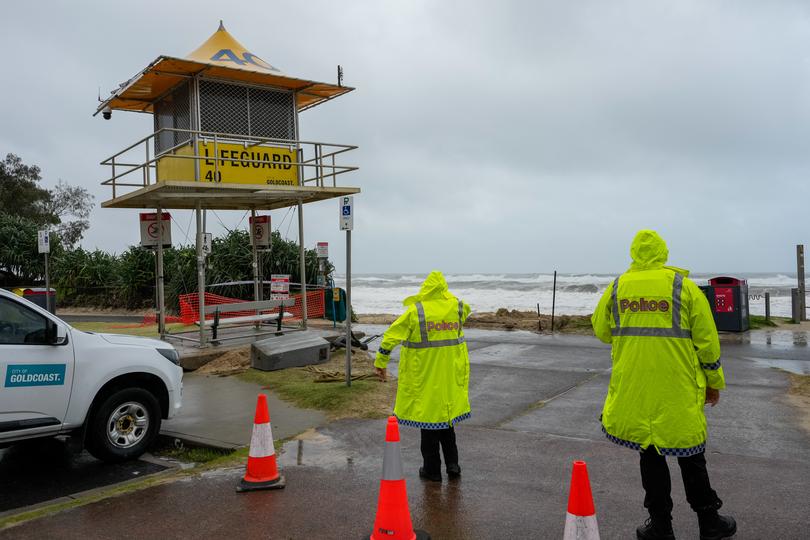
Lifeguard tower consumed by ferocious waves, sand erosion
07 Mar 2025 - 11:07 AM
Wild waves smash Main Beach in Surfers Paradise
07 Mar 2025 - 10:52 AM
Insurers ‘committed’ to supporting customers
07 Mar 2025 - 10:33 AM
‘Get home while it is still safe’: Supermarket’s grim update
07 Mar 2025 - 09:43 AM
Cyclone Alfred intensifies as it makes slow approach
07 Mar 2025 - 09:22 AM
Queensland premier updates state on Alfred’s destructive approach
07 Mar 2025 - 09:13 AM
Alfred brings tree down on home, two people taken to hospital
07 Mar 2025 - 08:25 AM
Cyclone Alfred landfall delayed, wild conditions to continue lashing states
07 Mar 2025 - 08:16 AM
‘Hope for the best, but prepare for the worst’
07 Mar 2025 - 07:59 AM
Surfer spotted in ocean as Cyclone Alfred just 140km away
07 Mar 2025 - 07:34 AM
NSW authorities issue warning as over 200mm rainfall recorded
07 Mar 2025 - 07:10 AM
Premier warns of Cyclone Alfred’s three waves
07 Mar 2025 - 07:07 AM
Premier says ‘preparation done’, Queensland ready
07 Mar 2025 - 06:42 AM
Latest information from BOM including hazards and advice
07 Mar 2025 - 06:39 AM
Albanese confirms federal assistance increased ahead of Cyclone Alfred
07 Mar 2025 - 06:34 AM
Albanese tells those near Cyclone Alfred to ‘be sensible’
07 Mar 2025 - 06:32 AM
PM shares the latest modelling of Cyclone Alfred
07 Mar 2025 - 06:30 AM
PM highlights resilience of Lismore locals
07 Mar 2025 - 06:24 AM
‘We’re all Australians helping each other out’
07 Mar 2025 - 06:23 AM
PM provides update on Cyclone Alfred
07 Mar 2025 - 06:06 AM
Bureau of Meteorology confirms Cyclone Alfred now 140km off coast
07 Mar 2025 - 05:48 AM
BOM warns locals not to fixate on category classification
07 Mar 2025 - 05:42 AM
BOM warns focusing on landfall location could put residents at risk
07 Mar 2025 - 05:38 AM
Cyclone Alfred now just 185kms west of Brisbane
07 Mar 2025 - 05:26 AM
‘Stay indoors’: Police commissioner’s blunt warning as risk increases
07 Mar 2025 - 05:20 AM
‘Heed the warnings’: SES commissioner’s urgent plea
07 Mar 2025 - 05:12 AM
Evacuation centres, must know emergency contacts and updates.
07 Mar 2025 - 04:30 AM
‘It is coming for us’: Mayor’s grim warning for Brisbane
07 Mar 2025 - 04:12 AM
Sunshine Coast mayor says residents waiting for potential chaos
07 Mar 2025 - 04:08 AM
Lismore Mayor Steve Kreig shares update for locals
07 Mar 2025 - 03:44 AM
What residents can expect in the next 48 hours
07 Mar 2025 - 03:41 AM
Seqwater confirms dam gates closed but looking for safe window for releases
07 Mar 2025 - 03:33 AM
Bureau of Meteorology shares new map of Cyclone Alfred’s path
07 Mar 2025 - 03:14 AM
What to know about Tropical Cyclone Alfred as the east coast wakes
07 Mar 2025 - 02:43 AM
Latest landfall update for Cyclone Alfred
Australian Army soldiers en route to help Lismore
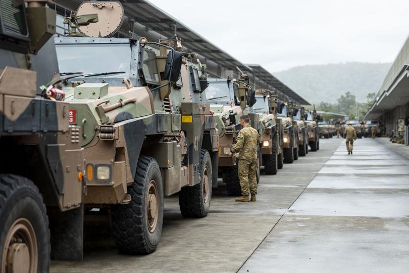
Photos have emerged of Australian Defence Force personnel departing for Lismore to assist with cyclone preparations.
The community is very much on edge as residents in Lismore’s CBD, north and south were told to evacuate last night.
Lismore Mayor Steve Krieg said the situation brought back many horrible memories for those involved in the 2022 floods.
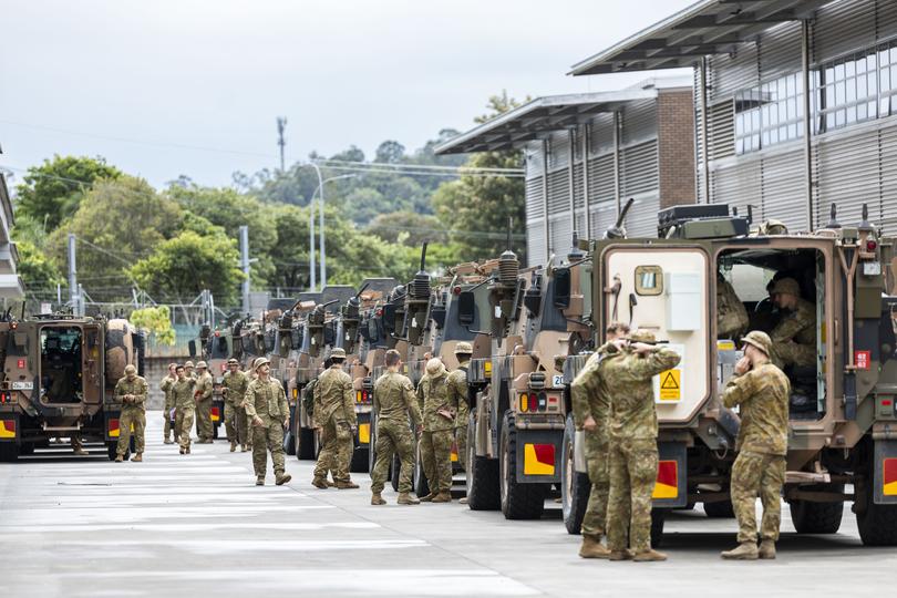
To provide some relief to the region, Prime Minister Anthony Albanese has sent ADF teams to the NSW Northern Rivers.
Mr Albanese confirmed on Friday morning he approved a request for 120 ADF personnel to depart immediately for NSW.
“They will support the SES with road clearance, sandbagging, clearing access to critical infrastructure, damage assessments and essential services,” he said.

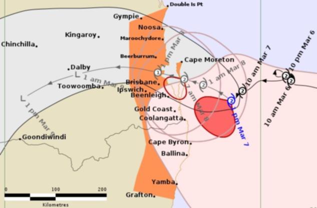
Latest prediction of where and when Alfred will cross
The latest map shows Alfred crossing late on Saturday morning or early into the afternoon but the bureau has warned people not to get too hung up on when it might make landfall.
“Because we will see very intense impacts well before the crossing ”Johnathan How told ABC.
The crossing point that looks to be around the Brisbane northern suburbs towards Redcliffe.
Alfred less than 100kms away as dangerous conditions ramp up
Packing wind gusts of up to 140km/h, Alfred is lurking about 125kms east southeast of Brisbane and 90kms east northeast of Gold Coast.
The Category 2 cyclone is moving west at the pace of a slow jog, about 8km/h.
And, while the cyclone proper is not expected to cross the coast until around midday on Saturday, the Bureau of Meteorology says heavy rain pounding nearby areas is expected to instensify throughout today.
“There is still a long way to go before the actual crossing but we already see dangerous conditions out there,” Johnathan How told ABC.
“(Alfred) will potentially move towards Moreton Island and North Stradbroke Island tonight and tomorrow morning.
“The danger is firstly with those huge waves and swell coming through that will exacerbate some of the coastal erosion that we have been seeing, especially at the high tide.
“We expect high tide in the next hour and the morning high tide comes through around three or 4am so that will worsen some of those impacts.
“As the system draws closer we will also see destructive winds which may also push down to northern parts ofthe Gold Coast and these are winds above 150km/h which can cause quite significant damage to trees and property and the rainfall becomes quite intense on Saturday morning.”
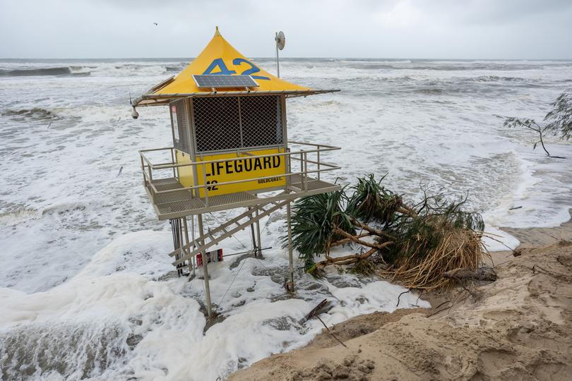
Lifeguard tower consumed by ferocious waves, sand erosion
The beloved lifeguard towers located on the golden sands of Surfers Paradise are being attacked by the wild waves caused by Cyclone Alfred.
The waves have eroded an enormous section of the beach, causing many to sit at risk of collapse.
One tower, number 40, had to be rescued by local emergency crews after its foundations eroded, being brought back to land.
Wild waves smash Main Beach in Surfers Paradise
A reader has shared a video of the wild waves smashing Main Beach on the Gold Coast as Cyclone Alfred makes its approach.
The video shows one of the world’s most well-known beaches nearly fully consumed by intese waves.
Insurers ‘committed’ to supporting customers
The Insurance Council of Australia has met with insurers in preparation for potential devastating damages brought by Cyclone Alfred.
The board said insurers have disaster response specialists on standby, however, urged Australians to prioritise their safety.
“The Board of the ICA met this morning to discuss this unfolding event and had a very constructive discussion with Assistant Treasurer Stephen Jones,” ICA chief executive Andrew Hall said.
“Insurers reiterated that insurers are committed to supporting customers through this event.
“A number of key insurers based in south-east Queensland with operations in impact zone are putting in place contingencies, however, their own staff may also be impacted by this event.
“Weather events are often unpredictable, and Tropical Cyclone Alfred is proving to be no exception. Safety is our absolute priority and it’s paramount those in the impact zone remain alert.
“While it’s still too early to know what the true impact of this weather event will be, we know that due to the population density in these areas that we may be looking at a very large number of claims.”
Read the ICA tips for policyholders impacted by Cyclone Alfred.
‘Get home while it is still safe’: Supermarket’s grim update
Supermarket giant Coles has updated residents in Queensland and New South Wales, announcing multiple closures for areas in the path of Cyclone Alfred, making a decision to get staff home “while it is still safe”.
“As a food retailer, we know we are an essential part of the communities we serve in times of natural disasters. As such, we have been working hard to keep our stores open as long as it has been safe to do so,” a Coles spokesperson said.
“As Cyclone Alfred gets closer, we have made the decision to begin closing our stores in highly impacted areas. This will ensure our team have time to get home while it is still safe.
“We will keep a close eye on the impacts from Cyclone Alfred, and make a decision on reopening our stores as soon as it is safe to do so.”
Cyclone Alfred intensifies as it makes slow approach
Tropical Cyclone Alfred has started to intensify as it creeps towards the Queensland and New South Wales coast.
The eye of the system, now measured 125km off the coast, is expected to reach Moreton Bay Island by 9am on Saturday, before starting to cross the mainland from 12pm.
Alfred has started growing tall cloud, giving the cyclone a more tropical nature.
“People between Cape Moreton and Yamba, including the Moreton Bay Islands should immediately commence or continue preparations, especially securing boats and property,” BOM said in a statement.
“People between Yamba and Grafton in New South Wales, as well as Brisbane and Double Island Point in Queensland should take precautions and listen to the next advice.”
Premier reminds Queenslanders they know how to deal with Alfred
“We are expecting some significant rainfall in the next 24 to 48 hours right across that system, and maybe even beyond,” Mr Crisafulli said.
“I really want to address that, and I want to address the significance of the potential for flooding. Thiss ystem remains a very broad one.
“Often when we see tropical cyclonesas they approach the coast, tha tband really does tighten. In this case, it is really large and slow moving, and that does represent the prospect of some significant rainfall over a long period of time.
“That rainfall does bring th erisk of river and creek flooding.
“But Queenslanders know how to deal with that. That has been proventime and time again.”
‘We continue to see waves north of 10 metres’
“There’s another high tide this afternoon and a slightly larger one tomorrow morning, a slightly larger one than this afternoon,” Mr Crisafulli warned.
“We’ll continue to watch that as the system approaches.
“We continue to see waves north of 10 metres off the coast. Indeed, some of the erosion we’ve seen at Main Beach, it does show you the force from which those waves hit the coast.”

