‘Take shelter now’: New alerts issued for flood in north Queensland
Five others on the boat were rescued.
A woman has died, and five others have been rescued, as an SES boat capsized when the group was caught in north Queensland dangerous floodwaters.
The boat capsized on Sunday morning at about 9am in the area of Ingham, 100km north of Townsville.
The woman was not an SES member.
Sign up to The Nightly's newsletters.
Get the first look at the digital newspaper, curated daily stories and breaking headlines delivered to your inbox.
By continuing you agree to our Terms and Privacy Policy.Her death is “heartbreaking”, Prime Minister Anthony Albanese said.
“My thoughts are with the family and the entire community at this awful time,” he said on X, formerly known as Twitter.
“The full support of the Queensland and Federal Governments is being deployed to assist with these floods.
“I have spoken with Premier Crisafulli and reiterated we will supply whatever resources are required to deal with this event.”
Ingham’s water levels will likely peak this afternoon at around the same height as floods that ripped through the area in 1967.
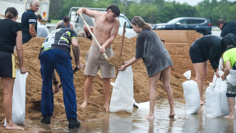
Townsville is evacuating thousands of residents from low-lying areas with more rain falling and even more water to come.
Heavy rain continues to impact areas of the Herbert and Lower Burdekin and North Tropical Coast, extending from Mackay to south of Cairns.
The rainfall has been fuelled by two tropical lows, but they are unlikely to form into cyclones.
However, cyclonic-like rain totals have lashed Townsville and surrounds with forecasts of 200mm to 400mm expected through Sunday into Monday.
The forecast falls come after isolated seven-day totals of more than 900mm hammered the North Tropical Coast.
The weekend rainfall could lead to flooded homes, businesses and properties, landslides and further road closures, the Bureau of Meteorology said.
“We’re likely to see widespread falls of anywhere from 200 to 400 millimetres almost on a daily basis, with isolated falls in excess of 900 millimetres possible,” senior meteorologist Dean Narramore said.
“We could even be talking about places in excess of one metre over the next few days. That is an incredible amount of rainfall.”
A severe weather warning is current from Innisfail to Ayr, south of Townsville.
A disaster declaration has been made for both Townsville and Innisfail.
There have been 16 rescues by swift water rescue teams, Premier David Crisafulli said.
“There is more rain to come and there is the prospect of record rainfalls and therefore that event being reached, those conditions,” he said.
He urged the community to “take the precautions, prepare for the worst, (and) listen to the advice”.
“Please don’t discount this,” he said. “This is a serious event and we’re asking people to heed the advice as it comes to hand.”
Authorities have deployed further resources to the state’s north with the Australian Defence Force assisting on the ground.
“The next 24 hours it is absolutely critical that you listen to emergency services and stay alive to the alerts,” state disaster coordinator Shane Chelepy said on Saturday.
“We are dealing with a dual event here.
“We are dealing with flash flooding from the heavy rain, but we are now seeing impacts from those major riverine systems which will bring riverine flooding into those communities.”
Townsville experienced its largest rainfall weather event in 120 years in January and February 2019.
About 3300 homes were damaged by floodwaters and about 1500 homes rendered uninhabitable.

A “take shelter now” warning was issued for Hinchinbrook on Sunday morning.
The Queensland Police emergency alert was sent out at 4.35am, urging residents to take shelter.
Ingham Pump Station is forecast to reach 15 metres early on Sunday afternoon, and the Ingham Showgrounds Evacuation Centre is open.
“If it is too dangerous to leave, get up as high as you can,” Queensland Police said.
Prepare-to-leave warnings were previously issued on Saturday for six suburbs in the city — Cluden, Hermit Park, Idalia, Oonoonba, Railway Estate and Rosslea.
Residents of these suburbs have now been asked to leave by midday.
An evacuation centre is open at Heatley for affected residents.
“If it is possible, please go with family and friends,” Crisafulli said.
“Ultimately, that’s the best place to be.
“There are evacuation centres that have been opened for those people who don’t have access to that.
“If you are in harm’s way, we’re asking residents to please seek safety and indeed if you need assistance, please reach out for it.”
Local worker Matthew James said he had seen first-hand how much damage torrential rain could produce.
“I still now am seeing places that have either just finished being repaired or completely refurbished after the 2019 floods,” he told AAP.
“So you can imagine if you lived in one of those houses that flooded, you’d probably be thinking now you might be in trouble.”
Originally published on AAP/7NEWS
