Brisbane weather: Queensland and other states set for ‘scorching end to winter’
The Bureau of Meteorology warned we were in for a ‘scorching end to winter’ even before monthly heat records toppled at the weekend. And it’s not stopping anytime soon.

With the spell of hot weather that we’re having, you would be forgiven for thinking we had completely leapfrogged over the end of Winter and kicked Spring off weeks before schedule.
You need only look at the snow-free ski fields — a number of which have closed most of their runs and look set to pull up stumps early — to signal how warm it’s been at the tail-end of Winter.
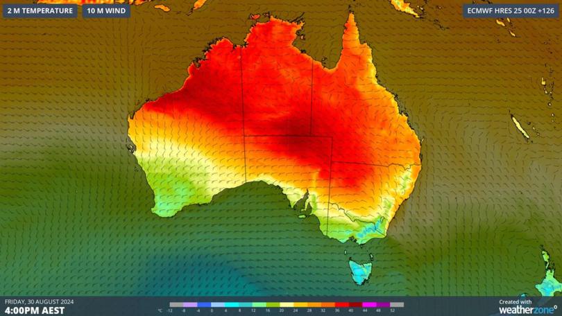
Top temperatures recorded over large parts of Australia at the weekend toppled heat records for August with some regions sweating through mid-to-high-30-degree days.
Sign up to The Nightly's newsletters.
Get the first look at the digital newspaper, curated daily stories and breaking headlines delivered to your inbox.
By continuing you agree to our Terms and Privacy Policy.Central Australia was particularly unforgiving, the outback town of Oodnadatta in South Australia recorded 38.5C on Friday and 39.4C on Saturday — about 16C above average and two degrees above the state’s winter temperature record, 36.5C also in Oodnadatta on August 12, 1946.
The SA towns of Marree and Roxby Downs also smashed their previous winter heat records by similar margins — the former recorded 37.3 (its previous winter high was 34.9C), while Roxby Downs reached 36.1C on Saturday (up from its previous high 34.6C).
Temperatures in the Northern Territory have been as much as 15C above average; while temperatures from far north Queensland all the way south to Melbourne have been two to 12C above average for several days now.
The Bureau of Meteorology expected as much, with meteorologist Angus Hines warning that Australia was in for “a scorching end to winter”. He also said that the heat and the dry, sometimes windy conditions were bringing moderate-to-high fire danger across the country — far earlier than what we consider ‘fire season’.
Why is it so hot?
A high pressure system is sitting over eastern Australia and the Tasman Sea, keeping skies clear and bringing northerly winds to much of the continent and warm air to the south.
While a high pressure system in June may bring cooler conditions — because heat is lost from the surface during long winter nights — by August, with its longer days and more intense sunshine, it means temperatures can climb.
Meanwhile, northwesterly winds pulled a pool of abnormally hot air over central Australia last week, leading to those record-breaking temperatures.
That hot air is expected to waft further southeast into NSW and Queensland as northerly winds develop ahead of a low pressure system and cold front, Weatherzone forecasts.
Is this August hotter than usual?
While it’s not unusual for a late-winter or early-spring burst of heat, this one is particularly exceptional.

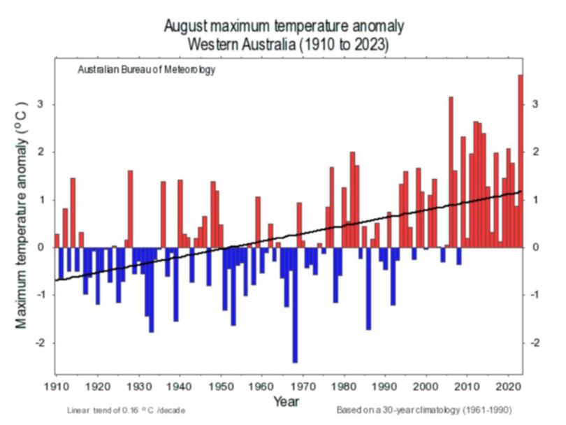
Last August was our second-warmest on record since 1910. Our three warmest Augusts have occurred since 2000, and monthly temperatures across Australia have routinely been higher than they were a century ago.
Add to that the world’s warming climate and run of global temperature records making each year — each month, even — the “hottest on record”.
What does it mean for summer?
In short: it’s not great.
As nice as it might seem to get a jump start on Spring, this winter heat wave has climate experts nervous.
ANU Professor Sarah Perkins-Kirkpatrick, who specialises in climate extremes, says it’s evidence climate change was nearing an irreversible boiling point.
“It shows winters are shortening… we’re getting a lengthening of the warmer parts of the year,” she told 9News.
Given this heatwave comes in another year that is slated to break annual global heat records, University of Melbourne climate expert Andrew King said it proves “climate change is upon us”.
“Historical averages are becoming just that: a thing of the past,” he wrote for The Conversation.
“That’s why this winter heat is concerning. The warming trend will continue for at least as long as we keep burning fossil fuels and polluting the atmosphere.
“Remember, this is only August. The heatwaves of spring and summer are only going to be hotter.”
The outlook until August 31
The Bureau of Meteorology meteorologist Sarah Scully said the “unseasonably warm” conditions will continue.
She said maximum temperatures across the country are set to be above August average.
Queensland’s temperatures are forecast to be 6C to 12C above the August average, Ms Scully said; coastal regions can expect temperatures in the mid-20C but tops in the mid-30s are predicted further inland.
Temperatures are far milder (in the mid-20s) across NSW, ACT and Victoria (around and below 20C). Temperatures in Victoria look set to remain 6C to 10C above average.
South Australia can also expect “maximum temperatures well above average”, Ms Scully said, with temperatures up to 14C above the monthly average in the west of the state.
WA, meanwhile, is set to tell two very different August ends. The state’s south, including Perth, can expect cloud cover and possible showers with top temperatures in the mid-20s for the week.
The northern regions, however, will swelter through top temperatures in the high 30s, with some regions breaching 40C on some days.
Similar temperatures can be expected across the Northern Territory, with much of the state forecast to sear in the mid-to-high-30s into September.
